
Gracias por apoyar a este sitio ❤️
Haz una donación
Haz una donación
Mapa topográfico Danau Sipin
Haga clic en el mapa para ver la altitud.
Gracias por apoyar a este sitio ❤️
Haz una donación
Haz una donación
Acerca de este mapa
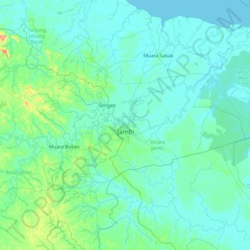
Nombre: Mapa topográfico Danau Sipin, altitud, relieve.
Lugar: Danau Sipin, Jambi, Sumatra, 36111, Indonesia (-2.29655 102.90623 -0.89655 104.30623)
Altitud media: 23 m
Altitud mínima: -2 m
Altitud máxima: 367 m
Gracias por apoyar a este sitio ❤️
Haz una donación
Haz una donación
Otros mapas topográficos
Haga clic en un mapa para ver su topografía, su altitud y su relieve.
Jambi
The total land area of Jambi city is 205.38 km2 (79 sq mi). Jambi City is located at the south-western portion of the Sumatran Basin, a low-lying area in Eastern Sumatra with an altitude of 0 to 60m above sea level. A segment of the Batanghari River, the longest river in Sumatra at 1,700 km (1,056 mi), flows…
Altitud media: 22 m
Gracias por apoyar a este sitio ❤️
Haz una donación
Haz una donación